


WEST MICHIGAN — Can straight line winds produce just as much damage as a tornado? The simple answer is yes.
When severe thunderstorms rip through West Michigan, they can produce damage in the form of downed trees, roof damage, power outages, and more. That damage could have been produced by straight line winds or a tornado, it all depends on if there was rotation or not.
When people think of wind damage, their first thought is often that it was produced by a tornado. However, more often than not, straight line winds are the culprit.
STRAIGHT LINE WINDS
The definition of a straight line wind is as simple as it sounds ... it's wind from a thunderstorm that moves in a straight direction, no rotation. What's more complicated is how it is formed.
Straight line winds are formed from strong thunderstorms, which include a strong updraft and downdraft. Below is a simplified version of a thunderstorm's life cycle. Thunderstorms love moisture, heat, and instability. For an updraft to form (the red arrows) there needs to be enough heat and instability so that air can rise. The higher the thunderstorm climbs and the taller it gets, the stronger it is.
What goes up, must come back down. Eventually, the particles of air turn into water droplets. They become too dense for the cloud to hold, and they come rushing down towards the surface in the form of strong wind gusts and some rain. That is when the downdraft is formed (the blue arrows). For a detailed explanation of each stage, click here.

A downdraft can produce what is called a downburst, which is described as powerful winds that descend from a thunderstorm and spread out quickly once they hit the ground. This can often cause damage similar to a tornado if it is strong enough. A downburst has two categories: a macroburst and a microburst.
The NOAA National Severe Storms Laboratory defines a macroburst as, "an outward burst of strong winds at or near the surface with horizontal dimensions larger than 4 km (2.5 mi) and occurs when a strong downdraft reaches the surface. To visualize this process, imagine the way water comes out of a faucet and hits the bottom of a sink. The column of water is the downdraft and the outward spray at the bottom of the sink is the macroburst. Macroburst winds may begin over a smaller area and then spread out over a wider area, sometimes producing damage similar to a tornado. Although usually associated with thunderstorms, macrobursts can occur with showers too weak to produce thunder."

A microburst is defined as a small, concentrated downburst that produces strong winds at or near the surface within a distance that is less than 2 miles. They are often short-lived, with wind speeds up to 150 mph.

If a straight line wind meets or exceeds 58 mph, then it is classified as severe by the National Weather Service. If the radar indicates wind speed at or above 58 mph associated with a thunderstorm, then the National Weather Service issues a Severe Thunderstorm Warning.
For additional types of damaging winds, including gust front, derecho, and haboob, click here.
TORNADO
The National Weather Service describes a tornado as, "violently rotating columns of air, extending from a thunderstorm, which are in contact with the ground."
According to the National Oceanic and Atmospheric Administration (NOAA), "most tornadoes are spawned from supercell thunderstorms, which are characterized by a persistent rotating updraft and form in environments of strong vertical wind shear." For more information about how tornadoes form, click here.
Tornadoes come in different shapes and sizes. The strength of the tornado is often placed in categories, which is described as the Enhanced Fujita Scale. It ranges on a scale from EF-0 to EF-5, which you can see below.

If a Tornado Watch is placed, it means that conditions are favorable or possible for a tornado to develop. This is a good time to have a plan in place with your family in case a Tornado Warning is issued.

If a Tornado Warning is in effect, it means that you need to take action! You need to seek shelter immediately, ideally in the lowest level of the building you are in.

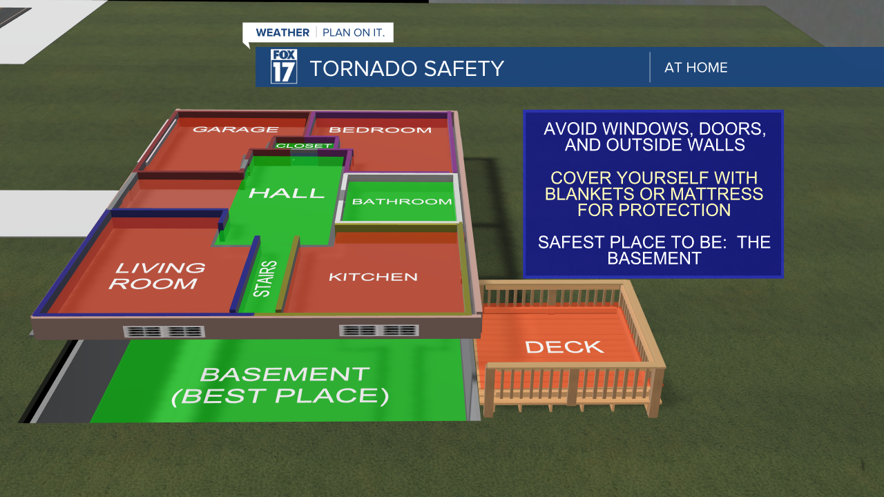
The best place to be during a Tornado Warning is in the lowest, most interior part of your home. If you don't have a basement, find a room with no windows and cover yourself for protection.
SO WHAT'S THE DIFFERENCE?
It all comes down to rotation. After a Tornado Warning, the National Weather Service conducts a survey of where the warning was issued. They then determine if the damage was from a straight-line wind or a tornado.
The best way to see the difference is by getting a view from above. The National Weather Service will often fly drones or use areal photography to determine if the damage was in a rotation or all the same direction.
Below is a capture from the National Weather Service in Huntsville. The image below shows that the trees fell in a rotation or circular movement. This would indicate that the damage is likely from a tornado.

The damage shown below is clearly from straight-line winds, as the trees have fallen in a straight line or parallel to each other.

For more information about how the National Weather Service conducts its damage reports, click here.
For your latest severe weather alerts, stay tuned with FOX 17 News on air and online. You'll receive a severe weather notification immediately via our FOX 17 Weather App, social media, our website, and on FOX 17 News.
Do you want to learn more about the weather? The National Oceanic and Atmospheric Administration offers an online lesson plan. It's easy to follow along with and provides incredible information about the weather at all layers. Click here!
