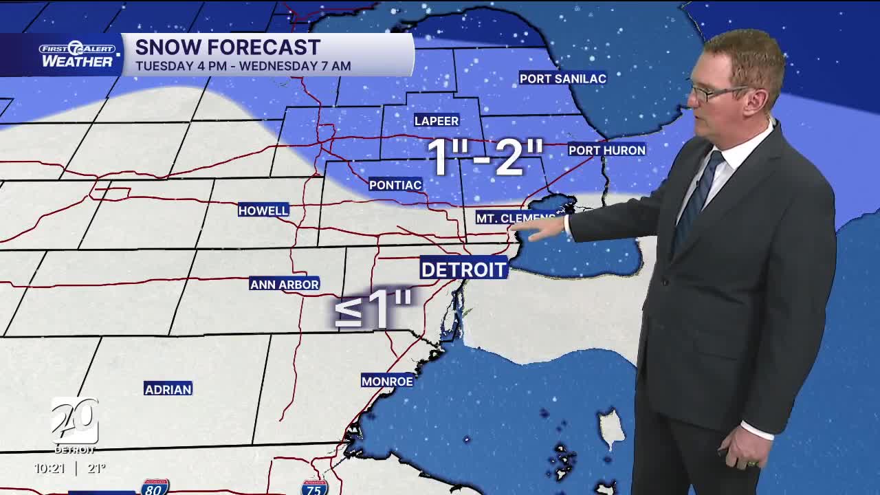


Colder temperatures tonight with single digit lows north of Detroit. Another chance for snow starts late Tuesday through Tuesday night with accumulation of 1"-2". The 2" areas will be north of M59.
Clouds filter back in Tuesday as a storm system moves in from the northwest. Snow showers will begin in the late afternoon across southeast Michigan and continue overnight. The steadiest snow and likely slipperiest roads will be between 8 to midnight Tuesday. After midnight snow will be lighter and spottier, which will lead to better travel conditions for the Wednesday morning commute (as long as the road is treated). High temperatures climb into the low to mid 30s Tuesday.
Flurries or a scattered snow showers may continue Wednesday morning with highs close to the freezing mark. As for snow Thursday, there is more agreement now than over the weekend that a strong storm will stay mostly to our south keeping most of us dry. There may be a few snow showers near the Ohio border. There is a small chance this forecast could change, so stay tuned.
Watch the forecast below
Tonight: Partly cloudy and cold. Lows of 7° to 14° with 14° in Detroit. Winds: Variable 5-10 mph. Wind chills will be close to the temps because of light winds.
Tuesday: Mostly cloudy. Snow by the evening. Highs in the low to mid 30s with 35° in Detroit. Winds: SSW 10-20 mph.
Tuesday Night: Snow expected with around an inch or less from Detroit and south. 1"-2" is likely north of Detroit.
Wednesday: Partial sun with a few snow showers possible. Highs in the mid to upper 30s and 38° in Detroit. Winds: W 15-25 mph.
Connect with 7 First Alert Meteorologists on Facebook and X:
Facebook: Dave Rexroth , Hally Vogel, Marisa Woloszyn, Mike Taylor
X: Dave Rexroth , Hally Vogel, Marisa Woloszyn, Mike Taylor
Current Conditions
- Humidity: 67%
- Dew point: 10°
- Pressure: 30.25 in
- Wind speed: 8 mph
- Wind direction: NNW
- Visibility: 10.0 mi
- Sunrise: 07:15 AM
- Sunset: 06:16 PM
