

Watch the forecast below
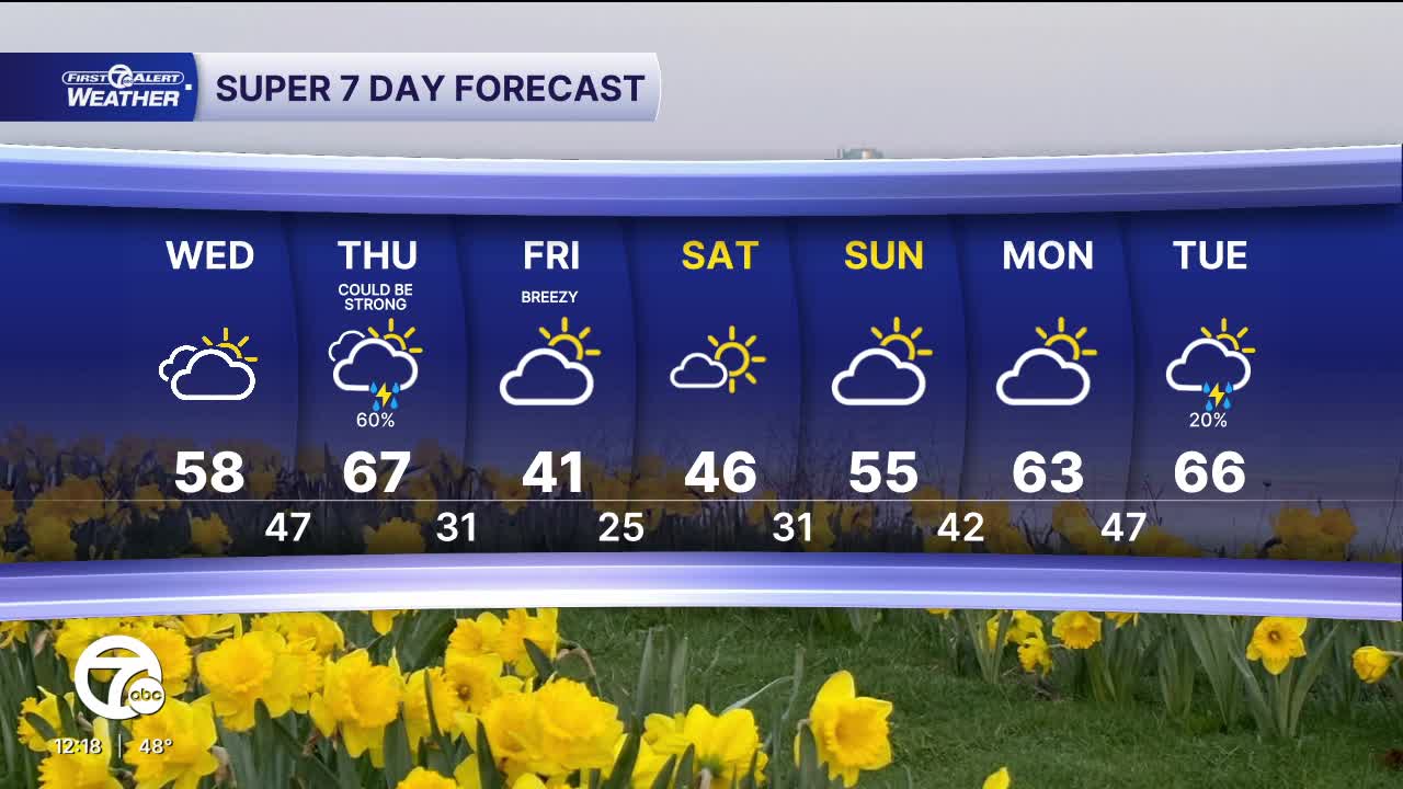
Temperatures continue to climb over the next few days with partly to mostly cloudy skies. Rain and storms chances return Thursday. Strong storms are possible Thursday evening south of M59.
Clouds stick around through much of the day but temperatures trend milder as the day goes on. After starting the morning in the low 30s, we've steadily warmed into the upper 40s and low 50s by the mid afternoon. Highs should top out in the upper 50s in most areas with some folks reaching the low 60s south & west of Detroit. It’s a gradual warm-up with a fairly quiet and dry setup.
A noticeable warm-up continues Thursday, which looks to be the warmest day, climbing into the mid to upper 60s and a chance of showers and even a few thunderstorms. An isolated storm could be severe around and south of I94 late Thursday and through Thursday evening.
Cooler air quickly follows Friday, dropping highs back into the low 40s. Temperatures then rebound through the weekend, with highs in the upper 40s Saturday, mid 50s Sunday, and nearing 60 by Monday under a mix of clouds and some sunshine.
Today: Warmer with partly to mostly cloudy skies and highs in the mid to upper 50s. Winds: S 5-15 mph.
Tonight: Partly cloudy skies with milder temps in the mid to upper 40s. Winds: SW 10-15 mph
Thursday: Mostly cloudy with rain chances increasing in the afternoon. Storms are possible as well late in the day and through the evening. An isolated storm could become severe. Highs will be in the mid to upper 60s with 67° in Detroit. Winds: SW 10-20 mph.
Connect with 7 First Alert Meteorologists on Facebook and X:
Facebook: Dave Rexroth , Hally Vogel, Marisa Woloszyn, Mike Taylor
X: Dave Rexroth , Hally Vogel, Marisa Woloszyn, Mike Taylor
Current Conditions
- Humidity: 28%
- Dew point: 25°
- Pressure: 29.95 in
- Wind speed: 11 mph
- Wind direction: S
- Visibility: 10.0 mi
- Sunrise: 07:27 AM
- Sunset: 07:51 PM
